Introduction to today's journey
Nestled in the northern expanse of the D'Aguilar Range, the Somerset Trail unfolds as a captivating journey through the layers of Australian bushland, revealing not only its diverse ecosystems, but also traces of a rich logging history. This scenic trail winds its way through dense eucalyptus forests and open woodlands on the top of the Mount Mee Plateau, edged by dramatic escarpments, offering panoramic views of the landscape below. Now protected as part of the national park, the Somerset Trail pays homage to the region's logging heritage supporting the growth of Brisbane in its fledgling days. The trail ends at The Gantry, a historic site remnant of the once thriving timber industry, now repurposed as the historic base for exploring all the trails over Mount Mee.
Today's journey continues along the backbone of the D'Aguilar Range following Range Road towards the Mount Mee plateau. Following a deep descent to cross Byron Creek before steeply rising again to the Somerset Trail. I follow the circuit to a spectacular view over Lake Somerset before continuing around the circuit to The Gantry.
Distance hiked today: 28.0km
Total distance hiked: 157.4km
Today's Journey
 |
As the first light of dawn breaks, I pack up and depart my makeshift camp before following the mostly descending Range Road continuing along the northern D’Aguilar Range. The path is leading me northward towards the Mount Mee plateau. The landscape is a tapestry of lush forests and rugged terrain illuminated by the early morning light casting a golden hue over the scenery. |
 |
I continue along the remote section of the road, the silence broken by the birdsong filling the air. The laughter of kookaburras echoes through the trees, along with the sweet warbles of the fairy-wrens flitting about. Occasionally, the remote stillness is interrupted by the rumble of a four-wheel drive vehicle passing by. |
 |
The road is becoming increasingly rough as it drops to a low saddle. As I reach the saddle, the landscape opens up briefly before the road begins its steep ascent over a forested hill continuing along the range. |
 |
Reaching the gated entrance of the Hangar Break firebreak, I decide to turn off the main dirt road and follow it to avoid the now increasing traffic of four-wheel drives. The rough path steeply descends towards the bubbling stream of Byron Creek, flowing at the bottom of the steep gorge. The descent is steep and challenging, but the sight of the crystal-clear creek provides a nice reward. The water sparkles in the filtered sunlight, as it winds its way towards the upper Pine River. Here I rest before crossing the brook to head up the other side of the valley. |
 |
I continue my journey along Hangar Break, now steeply ascending through the dense forest on the opposite side. As I am making my way up, I spot my first snake of this trek—a copper snake. The sighting is only a quick glimpse as it quickly slithers into the dense vegetation in fear of my approach. The forest gradually transforms from young straight trees to a more ancient forest of gnarly eucalypts. The track's gradient moderates as I approach the top of the Mount Mee plateau. |
 |
Although these trees are impressively large, they are nothing compared to the enormous giants that once covered this plateau. I reach the end of Hangar Break at an elevation of 550 metres above sea level. Here, I discover some old logging machinery, relics of a bygone era when the massive trees were felled and hauled away. These rusting remnants tell a story of the forest’s past. From this point, I follow K Break, a well-used four-wheel drive track. To avoid the traffic, I turn off taking an unmarked walking track leading towards the Somerset Trail. |
 |
Somerset Trail is the first dedicated walking track I have followed since the Greene's Falls Circuit at Mount Glorious. This is a popular walking circuit winding its way through the dense forest atop the Mount Mee Plateau. The air is filled with the sounds of nature, from the rustling leaves to the calls of bellbirds. I am now ascending to a height greater than the camp where I stayed last night, yet still not as high as the lofty Kluver’s Lookout. The forest canopy above is thick, casting dappled shadows on the path as I venture towards the lookout. |
 |
After ascending to 600 metres above sea level, I reach the top of the range and stand at the edge of a truly spectacular escarpment plunging dramatically down to the Brisbane Valley below. From here the trail turns to follow the top of the escarpment, offering panoramic vistas across the expansive valley. I see the distant hills of the Great Dividing Range across the other side of the Brisbane Valley, its blue-grey silhouette stretching as a narrow band across the horizon. |
 |
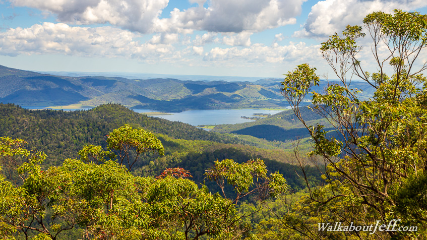
The escarpment gradually turns to reveal stunning views down to Lake Somerset, Brisbane’s most remote water supply lake. To my surprise, I discover an old leather sofa, strategically placed by some enterprising individuals, and not yet discovered by any of the rangers who police these lookouts. It is an unexpected yet welcome sight, offering a spot to rest and take in the scenery. |
 |
After my rest, I continue along the trail, which nearly doubles back on itself as it continues around the circuit gradually descending through the spectacular, colourful eucalypt forest. The trees here are a vibrant mix of greens, reds, and browns, their bark peeling away to reveal smooth, pale trunks beneath. The air is filled with the fresh, invigorating scent of eucalyptus, and I am hearing the rustle of leaves as a gentle breeze stirs the canopy above. The cloud cover is thickening overhead as the sun draws low behind me. |
 |
The trail continues its gradual descent before crossing a small stream, then rises to the gravel expanse of Lovedays Road. The sun makes a brief appearance, casting long, golden rays illuminating the canopy top. It is getting late, so I decide to follow the road to save some time, as it offers a more direct route compared to the otherwise meandering track.
|
 |
The sun is setting as I reach the end of the Somerset Trail, entering The Gantry Day Use Area. This spot marks the main road entrance to the northern end of the D’Aguilar National Park. The Gantry once served as the bustling centre of the timber milling industry on the plateau. The enormous shed still stands with the old mechanisms for lifting the huge logs still in place. I imagine the sounds of the saws and the hustle of workers as they processed and cut the timber here before it was transported down the mountain to build the expanding Brisbane city throughout the early 20th century. The area is now quiet, the echoes of its industrious past replaced by the serene sounds of nature. |
|