Introduction to today's journey
Today's journey departs Noosa North Shore at sunrise heading down the beach before following the southernmost sector of the Cooloola Great Walk through everglade swamp then following the road to the ferry across Noosa River. Once across the river, I hike through Tewantin following the northern end of the Sunshine Coast Coastal Walk before cutting across to Noosa Beach and walking to its far end at the mouth of the Noosa River to watch the sunset.
Distance hiked today: 23.9km
Total distance hiked: 729.5km
Today's Journey
 |
I depart Noosa North Shore shortly after sunrise, following the southern end of Teewah Beach towards the Noosa Headlands. |
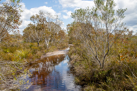 |
The unbridged mouth of the Noosa River forms a major barrier to getting to Noosa Beach, so I turn inland and follow the southernmost part of the Cooloola Great Walk through the wet and swampy Arthur Harrold Nature Reserve. |
 |
Once I have crossed the large swampy plain, the track heads up a low hill through thicker wetland forest where I reach the south end of the great walk and start walking along the road towards Tewantin. |
 |
The sealed road ends at the Noosa River, where I catch a ferry across to the other side. For walkers the ferry is a dollar. Aside from the bridge on Cooloola Way a long way upstream, this ferry is the only way vehicles can cross the river. |
 |
Once across the river, it is another two kilometres along the road through residential areas before I reach the centre of Tewantin. Here I am only three kilometres away from Wooroi Day Use Area where I had ended one of the days on the inland route. From here I find the start of the Sunshine Coast Coastal Track which I will be largely following down the length of the Sunshine Coast over the next few days. |
 |
The track is mostly footpath following the Noosa River downstream towards its mouth. This end of the river is very busy with a lot of boats and jetties. |
 |
After about an hour of following the river downstream, the track turns off and follows Weyba Creek upstream towards Lake Weyba. After hiking about half way up the creek, the path crosses a bridge to follow Noosa Drive. |
 |
Upon reaching the retail intersection at Sunshine Beach Road, I leave the Sunshine Coast Coastal Trail following a boardwalk continuing along Noosa Drive descending to Noosa Beach. |
 |
Upon reaching the beach, I hike its length to the rocky groyne at the mouth of the Noosa River. Here I watch the sun setting over the river and the full moon rising over Noosa Head. |
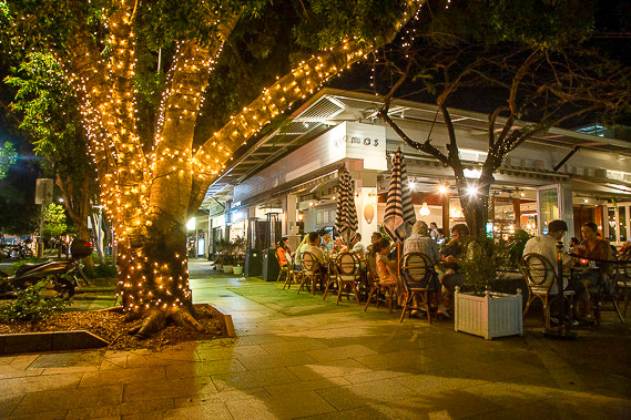 |
With the sunset complete, I return to the popular Hastings Street behind the beach where I explore its crowded and illuminated shopping and cafe precinct. Here I end the Cooloola leg of the trek. |
|
