Introduction to today's journey
Today's journey rises from Litoria Walker's Camp over a ridge and into the next gully before rising back onto the top of the Cooloola Sandmass where the forest cleared to scrubby heathland. Increasing elevation, the heathland goes back into tall forest rounding a couple of hills to the scant remains of Ramsey's Hut from where the track follows an old dirt road before dropping into a gully to leave the sandmass crossing a large heathland swamp to Dutgee Walker's Camp at the edge of the mirror smooth Noosa River.
Distance hiked today: 15.2km
Total distance hiked: 668.7km
Today's Journey
 |
A misty morning greets me as I leave Litoria at sunrise heading up the scrubby ridge here in the remote centre of the Cooloola sandmass. |
 |
I reach the top of the ridge hiking through the mist enshrouded scrubby bush before descending to a valley and rising through the forest on the other side. |
 |
The fog clears as I reach the top of the range where a large hill appears in the near distance. The forest becomes denser and taller as I approach it. |
 |
Heading around the hill, I reach a small clearing with the scant remains of Ramsey's Hut, a long-abandoned forestry hut from the times when the big timber here was milled and taken to the new settlements for building. |
 |
From Ramey's Hut, the track follows an old dirt road down the hill before turning off along a walking track continuing to descend to the bottom of a small valley. |
 |
The track heads out of the valley passing through scrubby swampland forest. The sandmass has disappeared behind me and there are no hills visible ahead of me. |
 |
The forest clears giving views across the vast heathland plain of the upper Noosa Valley. The sandmass is still visible to the left. |
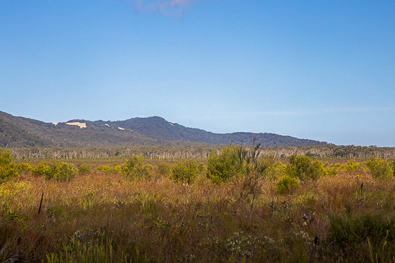 |
As I continue hiking along the track through the swampy heathland, I catch a glimpse of the Cooloola Sandblow which I will be hiking over tomorrow when I get back on top of the range. |
 |
I reach Dutgee Walkers' Camp on the shore of the mirror smooth Noosa River. Here I set up camp having arrived early with today having been relatively short.
|
 |
A magnificent sunset falls over the Noosa River with the trees of the everglade reflecting perfectly on the still river. |
|
