Introduction to today's journey
Today's journey starts with kayaking out from Military Wharf across the Pumicestone Passage to Bribie Island, where I walk up to the new channel before heading down the beach to Ocean Beach camping ground.
Distance hiked today: 13.3km
Total distance hiked: 863.3km
Today's Journey
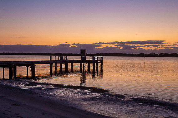 |
I watch the dawn and sunrise at Military Jetty at the edge of the Pumicestone Passage as the tide drops to its minimum. |
 |
When the sun is up over the horizon, I climb in the kayak and paddle across the very shallow passage, with the keel dragging in the soft mud in places. |
 |
I arrive near the top of Bribie Island at the Lions Day Use Area from where I arrange for the kayak to be taken back to the mainland as I continue exploring the coast. |
 |
Before heading down the beach, I walk about half a kilometre towards Caloundra to the new channel that has broken through the island at the location of the old lighthouse. The foundations of the lighthouse are still visible out in the ocean. When I was last here five years ago the lighthouse was on top of the dune showing how much erosion has occurred. |
 |
Returning down the beach back towards the Lions park, I continue following the long sweeping beach southward with Moreton Island now above the horizon. After an hour I reach the first of the old concrete military fortifications guarding the entrance of Moreton Bay. Here the ships pass close to Bribie Island as this is the only deep channel leading out of the bay. About two kilometres offshore is a vast array of sand banks just below the surface forcing the ships to stay in the channel. This made for a good military base to deter enemy ships during war time. |
 |
The Fort Bribie Trail heads a short distance inland passing the foundations of some of the houses that once stood here to support the military base. |
 |
Returning to the shore, I pass several more miltiary bunkers and gun emplacements, all deteriorating in the encroaching coastline. This was quite a heavily fortified area during World War II. |
 |
As I continue hiking down the beach, it is obvious this entire section of coastline has eroded a lot in recent decades. The remains of old trees are right down to the low tide line, creating interesting formations such as this first tree which looks like someone stepping out of the sand. |
 |
After what has been a relatively short journey today, I arrive at the Ocean Beach camping ground to set up camp. The tide is coming in fast and this section of beach is notoriously soft and difficult to walk along during the afternoon high tide. The next point of civilisation is about twenty kilometres further along the coast which I would be unlikely to reach before dark, so I set up camp here and have a relaxing afternoon. |
 |
I head out onto the beach to watch the sunset on the final day of this leg exploring the Sunshine Coast. Tomorrow I will head into the Moreton Bay Region just a short distance down the beach. |
|
