Introduction to today's journey
Today's journey departs Bokarina reaching Currimundi lake in the darkness, and continuing south to watch the sunrise over Dicky Beach before heading over Moffatt Head and around Caloundra into the entrance of Pumicestone Passage. From there I continue following the Sunshine Coast Coastal Walk to its end at Bell's Creek. From here I head slightly further south through some new residential areas before swinging around back to Pelican Waters.
Distance hiked today: 28.2km
Total distance hiked: 850.0km
Today's Journey
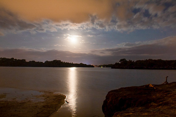 |
Setting off about an hour before dawn, I head to Currimundi Lake (named for its bats) to watch the full moon set behind the lake. I don't see any bats this morning. |
 |
The sky begins to brighten as I cross the walkway bridge across Coondibah Creek. Ships are sailing northward and southward to and from the port of Brisbane now not too far from here. |
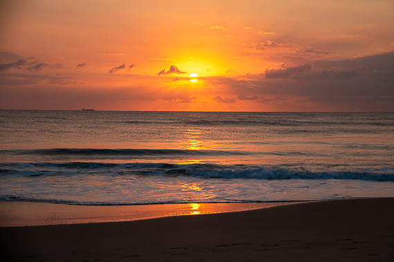 |
The track heads a little inland passing through the bush before coming out here at Dicky Beach where I watch the sun rise. The beach was named after the SS Dicky which was shipwrecked here following a storm in 1893. The shipwreck was removed a few years ago as it had badly deteriorated into pieces of rusting scrap metal. |
 |
From Dicky Beach, I walk along the sand to Moffatt Beach before following a track over the headland and descending here to Shelly Beach. |
 |
Crossing Wickham Point, the track descends to a boardwalk heading around the coast into the entrance of Pumicestone Passage. Across the narrow channel is the top of Bribie Island, with a view along the 25 kilometre long beach which I will be hiking along over the next two days. |
 |
The busy trail heads through Caloundra and follows residential areas at the edge of the calm waters of Pumicestone Passage, named for the huge quantities of pumice washing into here after the volcanoes along the Kermadec Trench above New Zealand erupt. |
 |
The track mostly follows the channel, except where apartment towers are right on the waterfront. The tide is quickly rising covering the sand flats with deep blue water. Numerous kayaks and other small boats are out on the water. |
 |
I continue following the passage south until reaching here at Bell's Creek. Here the residential housing of Pelican Waters abruptly ends with forests of mangrove growing on the other side of the creek merging into lowland farming. I have now reached the bottom of the Sunshine Coast and the end of the 106 kilometre long Sunshine Coast Coastal Walkway which began at Tewantin. |
 |
From Bell's Creek I follow paths through new residential areas heading inland before reaching the lagoon of Lamerough Creek West Environment Reserve. Here I follow the trail northward to its end. |
 |
From the end of the Lamerough Creek trail, I turn south eastward following the canals capturing the stillness of dusk as I approach today's destination back at the shore of Pumicestone Passage near Military Jetty. |
|
