Introduction to today's journey
Today's journey continues following Ocean Beach southward along the remote stretches of Bribie Island National Park until reaching civilisation at Woorim at the entrance of Moreton Bay. From here I hike around the bottom of the island to Bongaree from where I see the sunset over the Pumicestone Passage before continuing up to Bellara.
Distance hiked today: 33.3km
Total distance hiked: 896.6km
Today's Journey
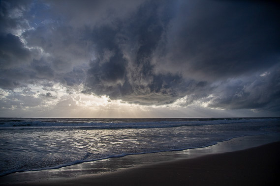 |
Rain clouds loom over the beach as I set off from Ocean Beach camping ground to follow the long beach towards Moreton Bay. Rain falling further south hides the distant sandhills of Moreton Island and the sandbar at the bottom of this island. It is not long before I pass the imaginary line where the Sunshine Coast ends and Moreton Bay Region begins. |
 |
Container ships pass in the distance, one heading towards the Port of Brisbane, and the other departing to some far flung destination. |
 |
As hours pass, the clouds gradually clear. I have breaks when reaching Welsby Lagoon, and here at Mermaid lagoon, then another one at Norfork Lagoon, and finally First Lagoon. |
 |
It is already midday when I finally arrive at the first signs of civilisation at another military bunker at the entrance of Moreton Bay. This marks the southern end of Bribie Island National park and the start of Woorim, the only settlement along the east coast of the island. |
 |
After walking through the town, I return to the beach and follow the coast heading around the bottom of the island. Across the relatively calm waters of Moreton Bay are the towering sandhills of Moreton Island, the higher range is the highest range of sandhills in the world, rising even higher than those on the Cooloola sandmass. |
 |
The coast swings around to a westerly direction. There are a lot of fallen trees on the eroding beach, and someone has gathered a lot of the driftwood into this enormous pile. In the distance, the blue hills of the D'Aguilar Range comes into view, the first hint I'm approaching the end of the northern circuit. Mount Nebo is the rounded hill standing out. From here I can also just make out the towering high rises of Brisbane City. |
 |
The sun starts to sink low in the western sky as I continue around the bottom of the island, now passing the last of the beaches before entering the southern end of Pumicestone Passage. |
 |
One in Pumicestone Passage, I follow a footpath past Bongaree, the southern suburb of the main populated area of Bribie Island. |
 |
The sun sets over Sandstone Point on the mainland in the area I will be exploring tomorrow morning. |
 |
I reach the Bribie Island bridge during dusk. This is the only dry access to the island and my way back to the mainland tomorrow morning. |
|
