Introduction to today's journey
Today's journey starts with a walk through Riverhills before following several forest paths continuing downstream along the river, including the amazing Mount Ommaney Walkway which re-emerges in suburbia at West Lakes and Jindalee before continuing along the path to the remains of a historic cement works. From there the trail leads away from the river over hills of suburbia going through Sherwood Forest and continuing to the end of the peninsula to cross the bridge to Indooroopilly.
Distance hiked today: 23.0km
Total distance hiked: 1237.4km
Today's Journey
 |
Departing Riverhills at first light, I follow several suburban streets until reaching the start of the Coucal Trail following the river downstream. |
 |
The well formed trail passes through thickly vegetated open eucalypt forest above the river, almost opaque from suspended silt. |
 |
The trail ends passing through Westlakes, with its large modern houses lining the river and a couple of small billabong lakes. |
 |
Upon reaching Mount Ommaney, the suburbia ends and a track runs around the bottom of the hill just above the river. Erosion along the banks from last years flooding is very evident but the river is very calm today as the tide starts rising pushing the muddy water upstream. |
 |
The track ends at a path running above the river for a couple of kilometres through Jindalee as I continue downstream. |
 |
The path continues through Seventeen Mile Rocks, named after this marked reef in the middle of the river, now turbulent with the incoming tide. The Indooroopilly Golf Course is directly opposite. |
 |
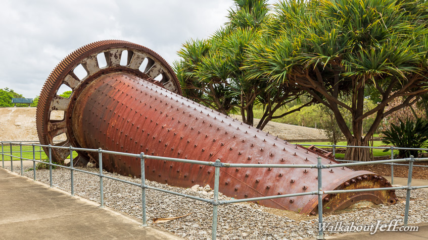
The path ends at the site of a large cement works which once stood here processing coral from Moreton Bay into cement. The factory closed years ago but some of the machinery and conveyor belts, along with the wharf used to transport the cement still remain hand have been landscaped into a park. |
 |
From the cement works, I follow a steep path up to the top of the hill before continuing through suburbia in Oxley and Corinda. |
 |
Upon reaching Sherwood, I head through the Sherwood Arboretum (also known as Sherwood Forest) where part of the track comes right to the river. Here I am following an avenue through native kauri trees. Many species of native tree has been planted in these gardens. |
 |
From Sherwood Forest, I continue following suburbia before crossing the Jack Pesch Bridge across the river into the centre of Indooroopilly where I stay the night. |
|